Between the Fond du Lac Dam and Minnesota and Wisconsin points, the St. Louis River Estuary is becoming a destination for many types of water recreation. Thanks to pollution remedies and controls combined with habitat restoration, the river is cleaner than it has been in decades. Despite these improvements, there are still safety hazards to consider before you recreate in the estuary. Whether you swim, paddle, duck hunt, fish, sail or pleasure cruise on the river, here are some tips for appropriate precautions.
A shorter, “quick tips” fact sheet of the following information can be downloaded from here.
Where in the St. Louis River Estuary can I swim, paddle and boat?
Swimming
Lifeguards are not present at any St. Louis River Estuary sites. Common places to swim include (Figure 1):
- Barker’s Island Inner Beach in Superior, Wisconsin
- Munger Landing in West Duluth, Minnesota
- Minnesota Point 15th Street Harbor Side in Duluth, Minnesota
- Minnesota Point Harbor Side Sky Harbor in Duluth, Minnesota
If you’d prefer a swimming area with a lifeguard, the closest to the estuary is Park Point Beach Recreation Area, which is on the Lake Superior side of site #4 of the list above.
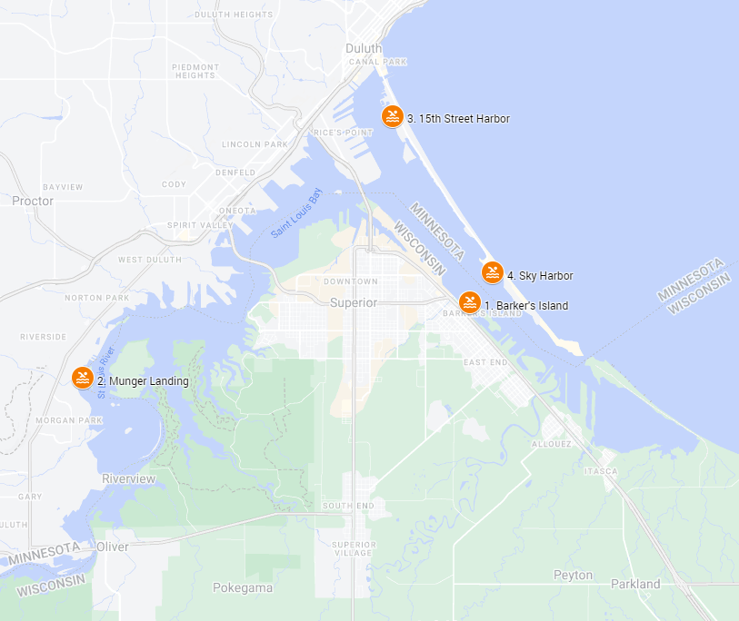
Figure 1. Map of public swimming locations in the St. Louis River Estuary. Credit: Kelsey Prihoda/Minnesota Sea Grant.
Paddling and Boating
Whitewater rafting
Between Floodwood and Cloquet, Minnesota, the St. Louis River features the only whitewater rafting opportunities in the entire state of Minnesota. Many of the rapids along this stretch of river should only be attempted by experienced paddlers or under the supervision of an experienced guide.
St. Louis River National Water Trail
From the Fond du Lac Dam to Lake Superior, the St. Louis River has been designated as a national water trail with 11 loop trails for paddlers of all skill levels, abilities and watercraft types. The St. Louis River Estuary National Water Trail Map is available online, and paper copies are available at local businesses.
The Paddle Safe Twin Ports website features 10 launch sites in Western Lake Superior and the St. Louis River Estuary and provides descriptions for each site, including paddler experience level ratings.
Important safety tips for swimmers, paddlers and boaters
Never swim or paddle alone.
It’s always more fun to enjoy the water with family or friends, but more importantly, it’s also a safe thing to do. Before your group heads out, tell a reliable family member or friend the 4 Ws:
- Who is in your group.
- Where you are going.
- When you expect to return.
- What to do if you don’t check in on time.
Wear a life jacket.
According to the U.S. Centers for Disease Control and Prevention (U.S. CDC, 2023), drowning is the leading cause of death for young children ages 1-4 and the second-leading cause of death in children 5-14. Life jackets can prevent drowning during swimming and boating. Of the 658 boating-related deaths reported by the U.S. Coast Guard in 2021, 83% of these people were not wearing life jackets (U.S. CDC, 2023).
The most important safety tip is to buy or borrow a life jacket, bring it with you and wear it (Figure 2). Children, inexperienced swimmers (both kids and adults) and all boaters should wear a U.S. Coast Guard-approved, colorful life jacket that is appropriate for their weight, chest size and the type of water activity they are doing.
Federal law requires children under 13 to wear a U.S. Coast Guard-approved life jacket while underway in a boat unless they are located below decks or in an enclosed cabin.
Minnesota state law requires children under 10 years old to wear a properly fitted life jacket while a boat is underway (Minnesota Department of Natural Resources, 2023). A readily accessible and wearable life jacket is required for each person onboard a boat — this includes canoes, kayaks, stand-up paddleboards, paddleboats and waterfowl boats.
In Wisconsin, all vessels, including canoes, kayaks and paddleboards, must have at least one U.S. Coast Guard-approved life jacket for each person on board. Life jackets must be in good condition, readily accessible and of the proper size for the intended wearer. Children under the age of 13 are required to wear a life jacket while a boat is underway (Wisconsin Department of Natural Resources, 2022).
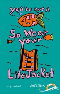
Figure 2. Life jacket safety messaging from the Great Lakes Water Safety Consortium. Image credit: Lauryn Dewhurst.
Never go in or near the water while under the influence of alcohol or drugs.
According to the CDC (2023), alcohol use is involved in up to 70% of deaths associated with water recreation among adolescents and adults. Alcohol is a factor in about one in five reported boating deaths. Drugs and certain prescription medications can also increase the risk of drowning.
Know the weather.
Check the weather forecast frequently — wind, waves and air temperature can change rapidly, especially near Lake Superior and in the Duluth-Superior Harbor (Figure 3). The National Weather Service issues nearshore marine zone forecasts for the Great Lakes and is a great resource for swimmers, paddlers and boaters. Windy.com provides an interactive, animated map of wind direction and speed.
Pay attention to changing conditions and, if they get worse, get off the water right away.
Seek shelter immediately if you hear thunder or see lightning.

Figure 3. Safety reminder to check the weather from the Paddle Safe Twin Ports website.
Practice “leave no trace” principles.
The St. Louis River Estuary is an important and beautiful place. Thanks to many years of hard work, this ecosystem is being restored and is now a much healthier environment and a much safer place to recreate. Enjoy the river respectfully, and practice these “leave no trace” principles:
- Dispose of waste properly.
- Leave what you find.
- Protect aquatic vegetation, especially wild rice.
- Respect wildlife.
- Be considerate of other visitors.
Be aware of depth, current and debris.
Areas of the St. Louis River Estuary can be calm on the surface and have strong underwater currents and abrupt drop-offs below, so use only designated public access points or common swimming sites. Keep in mind that the main river channel is deeper and typically has a faster current than backwater areas, particularly after a large rain event. Large rain events and flooding can wash debris from land into the water and move it downstream. Seiche events, when Lake Superior sloshes water into the St. Louis River, can also dislodge woody debris that had previously been beached.
- Usually, the St. Louis River flows downstream to Lake Superior, with the strongest currents in the deeper, main channel. However, when wind and air pressure conditions are right, Lake Superior water can be forced into the estuary. These seiche events can reverse the flow of water as far as Highway 23 (20 miles!) and raise water levels by up to two feet. (https://infosportwashington.cee.wisc.edu/new_model_surfcurr_core.html)
Consider water temperature and water quality.
The river temperature can fluctuate, particularly after a large rain event or during a seiche. Seiche events that push Lake Superior water upriver can cause the water temperature to drop quickly. Hypothermia can happen rapidly. In 50° F water you will be unconscious within an hour (Figure 4). A good rule of thumb is if the air temperature and the water temperature add up to be less than 120° F, a wet suit or dry suit should be worn while in or on the water. More information on hypothermia, including a video on how to unpack and deploy a hypothermia rescue kit, can be found on Minnesota Sea Grant’s website.
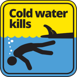
Figure 4. Hypothermia safety messaging from the Paddle Safe Twin Ports website.
From Memorial Day to Labor Day, the Minnesota Department of Health and Wisconsin Department of Natural Resources monitor several recreational sites in the St. Louis River Estuary for Escherichia coli bacteria. The presence of E. coli in water samples means that other germs that cause illness could be in the water. E. coli are found in the digestive system of mammals and birds and are excreted in feces. E. coli is an indicator organism because it is not possible to test for every type of germ that could cause illness. If the concentration of E. coli is too high in water samples collected at monitored sites in Minnesota or Wisconsin, it could lead to a swimming advisory or beach closure. Before you head to the water, you can check to see whether monitored sites have a posted advisory or closure. Go to mnbeaches.org to check the status of monitored North Shore sites in Minnesota, and in Wisconsin visit the beach closings and advisories map. These sites also contain information on reasons for advisories and closures, frequently asked questions and tips for staying safe at the beach. Additional information about E. coli impairments in Duluth can be found in the Duluth Area Beaches Total Maximum Daily Load Report.
Even if there are no elevated bacteria advisories, conditions can change quickly, so follow standard precautions – avoid swallowing water and rinse and towel dry after swimming. Exercise special care with small children and pets, as they tend to ingest more water.
Aside from germs that may cause illness, you should also be aware of the potential for stormwater pollution like chemicals, garbage, oil and fertilizers that are discharged into the St. Louis River Estuary at creek mouths and storm sewer outfalls, especially after rain events. Look at Minnesota’s Impaired Waters Viewer or Wisconsin’s Impaired Waters List to learn what water quality impairments exist in estuary waters.
Harmful algal blooms: When in doubt, stay out!
Blue-green algae, which are actually bacteria called cyanobacteria, can grow quickly under the right conditions (i.e., warm, calm, sunny and water temperatures over 75° F) and form blooms. Cyanobacteria are a natural part of aquatic environments, and algal blooms have occurred for many centuries. Some, but not all, types of cyanobacteria are capable of producing cyanotoxins, which can make humans and animals sick. Cyanobacteria blooms typically occur in summer and early fall. They may make the water look like pea soup or a spill of green paint (Figure 5). There is no way to tell if an algae bloom is toxic just by looking at it. So, when in doubt, stay out!
For more information, or to report a suspected harmful algal bloom:
- More information from the Wisconsin Department of Health Services.
- In Wisconsin, call 608-266-1120 or complete this online Harmful Algae Bloom Illness or Sighting Survey.
- More information from the Minnesota Department of Health.
- In Minnesota, observations of large or very dense blooms can be reported using the bloomWatch app.
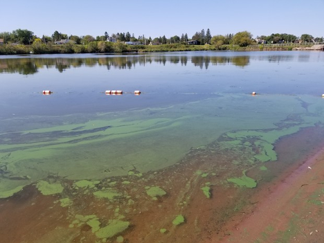
Figure 5. Algae bloom at Barker’s Island Beach in Superior, Wisconsin, in 2021. Image credit: Hannah Ramage/Lake Superior Natural Estuarine Research Reserve.
Avoid active St. Louis River Area of Concern construction sites.
The current goal stated in the “St. Louis River Area of Concern Remedial Action Plan” is to complete remediation and habitat restoration construction projects in 2026 (St. Louis River Area of Concern Coordinators, 2023). Until then, before venturing out, it’s good to be aware of active construction sites in the St. Louis River Estuary. Through 2026, click on the Anticipated Field Work link on the St. Louis River Alliance’s website to learn where project work is planned each year.
Additional considerations for paddlers and boaters
Identify your vessel.
Ensure that your vessel is in good condition and is the appropriate type for the locations where you will be paddling. Place a vessel identification sticker on your canoe, kayak, stand-up paddleboard or rowboat that includes your name and contact information. The U.S. Coast Guard and U.S. Coast Guard Auxiliary provide free “If found – contact” vessel identification stickers (Figure 6), or you can make your own sticker. This provides crucial information to anyone who observes a vessel with no paddler onboard — a way to begin searching for the vessel owner.
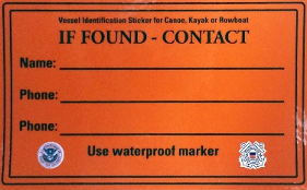
Figure 6. U.S. Coast Guard Auxiliary vessel identification sticker.
Check the shipping traffic.
Check the shipping traffic before you go to identify locations that may be heavily trafficked by commercial vessels, as those locations should be avoided. Shipping traffic for the St. Louis River Estuary can be easily viewed on the Paddle Safe Twin Ports website. Stay at least 100 yards away from freighters and harbor docks. These vessels, which can carry up to 68,000 gross tons of cargo, are difficult to maneuver and require a very long distance to stop. They produce a wake that is large enough to capsize a canoe, kayak, stand-up paddleboard or other small vessel that gets too close.
Complete a float plan.
Float plans provide an easy way to communicate your paddling route and timing to someone you trust. Float plans are available on the Paddle Safe Twin Ports website.
Be aware of fish consumption advisories.
For people who also fish in the estuary, safe recreation is tied to safe fish consumption. The Minnesota Department of Health and Wisconsin Department of Natural Resources provide both statewide safe eating guidelines and waterbody-specific safe eating guidelines for the general population and sensitive populations. The consumption advice is updated about once every five years. Minnesota’s guidelines can be found here and Wisconsin’s advice for the estuary can be found here.
What is an estuary and how do they differ from inland lakes?
An estuary needs a river and a lake or ocean in order to exist. In the Great Lakes, freshwater estuaries occur in partially closed areas where waters from rivers or streams meet the waters of a Great Lake. Storms and seiches cause two chemically different water bodies to mix. In the St. Louis River Estuary, a seiche occurs when Lake Superior pushes, or sloshes, upstream, reversing the flow of the downstream river current. Seiches can be caused by wind and changes in barometric pressure. Depending on its strength, the effect of a seiche can be observed as far the Highway 23 bridge – 20 miles upstream!
Estuaries are different from inland lakes because lakes don’t require a river. Inland lakes have still, standing water. The mixing and changes in current due to seiches that are hallmarks of freshwater estuaries do not occur in inland lakes. The plant and animal life supported by these two ecosystems is different. Estuaries can vary in depth, water temperature and substrate type. The St. Louis River Estuary water is hard to see through. Its dark color is caused by tannins from coniferous trees and bogs in the upstream portions of the St. Louis River watershed. The dark color does not mean that the water is “dirty” or “polluted,” but it can make it hard to see obstructions or the channels’ depth. The St. Louis River Estuary supports a diversity of plant life. Shallower areas can become rich with plants that grow above or below the water surface, and algae blooms can happen as the water temperature rises in the summer, especially after storms.
Why is the St. Louis River Estuary important?
The freshwater St. Louis River Estuary is a unique and important ecosystem. It is a nesting area for resident birds and a critical stopover area for migratory birds. It is a nursery for Lake Superior fish, like lake sturgeon, walleye and channel catfish. It is also important culturally. “Gichigami-ziibi,” the St. Louis River, is the traditional and current homeland of the Anishinaabe (Ojibwe) people and other Indigenous peoples before them. The estuary is home to the largest port by tonnage on the Great Lakes, the Port of Duluth-Superior, and is a critical, regional economic driver.
Spending time in or near the St. Louis River Estuary is the best way to see, feel, hear and smell all the wonderful things that make this ecosystem so unique and important.
St. Louis River history
Spirit Island, located in the St. Louis River Estuary, is the place where the “food that grows on the water” (“manoomin” or wild rice) was first encountered (Schuldt, 2015) and is central to the Anishinaabe migration story. Long before European fur traders first arrived, Gichigami-ziibi, the Lake Superior River, provided food, medicine and building materials for the Anishinaabe and was an important transportation route for trading, hunting and gathering.
According to the website “St. Louis River Estuary the Stories and the Science,” the arrival of Europeans to the area in the 1790s was motivated by the fur trade. Duluth and Superior were developed using rock mined from quarries beginning in the 1800s and opened to settlement after the U.S. and Ojibwe tribes signed treaties in 1842 and 1854. The connection to the railroad in 1869 and the opening of the Duluth ship canal in 1871 resulted in rapid growth of several industries including coal, iron, grain, lumber and shipping. These industries used the St. Louis River as a source of water and as a waste disposal site, prior to environmental regulation and wastewater treatment. Remnant underwater foundations and pilings from these industries can still be found in portions of the estuary. The Western Lake Superior Sanitary District began operation in 1978, improving water quality.
In 1987, the lower 39 miles (63 km) of the St. Louis River, including the estuary, were listed as one of the 43 Areas of Concern on the Great Lakes in the U.S. and Canada Great Lakes Water Quality Agreement. It was not until the launch of the U.S. Environmental Protection Agency’s Great Lakes Restoration Initiative in 2010 that more funding became available for Areas of Concern to remediate contaminated sediments and restore aquatic habitat. The “St. Louis River Area of Concern Remedial Action Plan” outlines management actions needed to remove each of the nine beneficial use impairments in this Area of Concern, and it is updated annually. The current goal is to complete remediation and habitat restoration construction projects in 2026, with the remaining beneficial use impairments to be removed by 2029, leading to delisting by 2030 (St. Louis River Area of Concern Coordinators, 2023). According to the “2022 St. Louis River Remedial Action Plan,” as of the end of September 2022, 51 of the 80 planned management actions are either complete or need no further action.
For questions about this information, please contact Kelsey Prihoda, Minnesota Sea Grant, priho011@d.umn.edu or (218) 726-6195. A shorter, “quick tips” fact sheet of this information can be downloaded from here.
References and Resources
Centers for Disease Control and Prevention. (2023, June). Drowning Prevention: CDC’s Injury Center Uses Data and Research to Save Lives. https://www.cdc.gov/drowning/pdf/CDC-DIP_At-a-Glance_Drowning_508.pdf
Lake Superior Streams. (2009). Lake Superior Streams: Community Partnerships for Understanding Water Quality and Stormwater Impacts at the Head of the Great Lakes (http://lakesuperiorstreams.org). University of Minnesota-Duluth, Duluth, MN 55812.
Leave no Trace. (2021). The 7 Principles webpage. https://lnt.org/why/7-principles/
Minnesota Department of Health. (2022, October 26). Harmful Algal Blooms webpage. https://www.health.state.mn.us/diseases/hab/index.html
Minnesota Department of Health. (no date). Minnesota Lake Superior Beach Monitoring Program webpage. https://mnbeaches.org/
Minnesota Department of Natural Resources. (2023). Minnesota Boating Guide 2023. https://files.dnr.state.mn.us/rlp/regulations/boatwater/boatingguide.pdf
Minnesota Sea Grant. (2022, October 24). Paddle Safe Twin Ports website. https://www.paddlesafetwinports.org/
Minnesota Sea Grant. (no date). Hypothermia: Understanding and Prevention webpage. https://seagrant.umn.edu/programs/recreation-and-water-safety-program/hypothermia
Saint Louis River Alliance. (no date). St. Louis River National Water Trail webpage. https://www.stlouisriver.org/national-water-trail
Saint Louis River Area of Concern Coordinators. (2023, February). St. Louis River Area of Concern 2022 Remedial Action Plan (October 1, 2021 – September 30, 2022). https://apps.dnr.wi.gov/swims/Documents/DownloadDocument?id=338305814
Schuldt, N. (2015, October 6). Gitchi-Gami-Ziibi: The Lake Superior River. American Rivers. https://www.americanrivers.org/2015/10/gitchi-gami-ziibi-the-lake-superior-river/
Stressor Gradients and Spatial Narratives of the St. Louis River Estuary (2010 – 2015). St. Louis River Estuary the Stories and the Science. https://stlouisriverestuary.org/
United States Coast Guard Auxiliary. (no date). Paddle Safety website. https://wow.uscgaux.info/content.php?unit=054-26-02&category=paddle-safety
United States Coast Guard Boating Safety Division. (2023, September). A Boater’s Guide to the Federal Requirements for Recreational Boats. https://www.uscgboating.org/assets/1/AssetManager/Boaters-Guide-to-Federal-Requirements-for-Receational-Boats-20230901.pdf
Wisconsin Department of Health Services. (2023, August 7). Algae webpage. https://www.dhs.wisconsin.gov/algae/index.htm
Wisconsin Department of Natural Resources. (2022). The Handbook of Wisconsin Boating Laws and Responsibilities. PUB-LE-301 2022. Published by Boat Ed, a division of Kalkomey Enterprises LLC, Richardson, TX. https://widnr.widen.net/s/0vw8hwrae3
Wisconsin Department of Natural Resources. (no date). St. Louis River Area of Concern webpage. https://dnr.wisconsin.gov/topic/GreatLakes/StLouis.html
Wisconsin Department of Natural Resources. (no date). Wisconsin Beach Health: Beach Advisories and Closings webpage. https://dnr.wisconsin.gov/topic/Beaches/Advisories.html/