
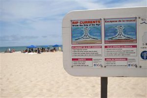
Warning signs at a beach are one tool to raise awareness about rip currents but there others.
Credit: Sea Grant
Rip currents occur where a longshore current meets a physical barrier such as a peninsula, headland, long groin, harbor breakwater, nearshore reef, or shoal, and is deflected lakeward. These currents also occur along an open beach where there is less resistance to lakeward flow, such as places where the breaking waves are lower, or where there is a gap or trough in the nearshore sand bars. Once a rip current is established, it can scour its own channel through the bars and be a relatively stable current until wave conditions change. Rip currents are usually narrow. Swimmers can escape them by swimming perpendicular to the flow (parallel to shore) a short distance. For more information, see www.ripcurrents.noaa.gov
RIP CURRENT INFORMATION SOURCES
The following list includes a few of the many resources available for Rip Current Information:
- National Weather Service/NOAA www.ripcurrents.noaa.gov/
- Selected Sea Grant Program web sites:
- United States Lifesaving Association www.usla.org.
- Great Lakes Beach & Pier Safety Task Force www.respectthepower.org/.
- Misc Signs & Brochures www.ripcurrents.noaa.gov/signs-brochures.shtml.
- Misc Rip Current Photos www.ripcurrents.noaa.gov/graphics.shtml.
- Misc Animations of Rip Currents www.ripcurrents.noaa.gov/multimedia/RIPANIME.mov and also see www.sciencemag.org/sciext/vis2005/show/rip.html.