[su_row] [su_column size=”1/2″ center=”no” class=””]
Storm Surges
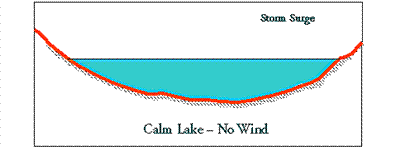
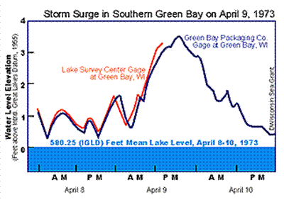
Storm surges are temporary rises in water level caused by storm winds blowing across miles of open water and dragging some water towards the down-wind shore. This causes a build-up in water level along the down-wind shore. The temporary rise in water level may also be called a storm set-up, wind set-up, storm-induced rise, or storm rise. Storm surges occur on ocean coasts as well as on Great Lakes coasts. The image below shows an extreme storm surge in the southern end of Green Bay at the City of Green Bay, Wisconsin.
[/su_column] [su_column size=”1/2″ center=”no” class=””]

Lake Surge. Credit: UW Sea Grant
[/su_column] [/su_row]
A storm surge typically rises about as fast as the onshore wind speed rises, but with a little time delay. The surge typically lasts about as long as the strong winds are blowing onshore. A storm surge may last all day. Great Lakes storm surges range from one to eight feet in height. Storm surges caused by hurricanes raise sea levels on ocean coasts by ten to twenty feet or more.
The greatest surges on the Great Lakes occur at the eastern and western ends of Lake Erie and in shallow bays exposed to long distances of water surface across which storm winds blow. The lower end of Green Bay is one of those locations where large surges can occur. Storm surges are probably negligible on open shores of small islands and on the ends of peninsulas or points of land.
On enclosed water bodies, storm winds lower the water level on the upwind shore. The drop in water level is called a set-down and is similar in magnitude to the storm surge. On Lake Erie, a storm surge at Buffalo on the eastern end of the lake and the set-down on the western end of the lake have caused a water level difference of up to 15 feet.
The NOAA Great Lakes Environmental Research Laboratory web site has information about a series of storm surges that occurred across the Great Lakes on October 25-27, 2001.

Credit: UW Sea Grant
Seiches
Seiches are periodic oscillations of water level set in motion by some atmospheric disturbance passing over a Great Lake. The disturbances that cause seiches include the rapid changes in atmospheric pressure with the passage of low or high pressure weather systems, rapidly-moving weather fronts, and major shifts in the directions of strong winds. Seiches exist on the Great Lakes, other large, confined water bodies, and on partially-enclosed arms of the sea.
The intervals (or periods) between seiche peaks on the Great Lakes range from minutes to more than eight hours. One or more seiches following a storm surge may cause repeated flooding of low-lying property. Small seiches (less than a foot high) are an everyday occurrence on the Great Lakes.
Edge Waves
A rare and dangerous form of storm rise can occur when there is no local storm activity. On May 31, 1998, a line of large and damaging thunderstorms called a derecho (day-ray-co) formed in South Dakota and raced across Minnesota, Wisconsin and Lake Michigan at roughly 50 miles per hour, all the way to New York. Wind speeds increased as this storm system moved swiftly through the night; reaching nearly 100 miles per hour in Michigan.
This rapid squall line created a storm surge (or “wave”) that traveled southeast across Lake Michigan with the squall line very early in the morning of June 1, reaching and reflecting off the shore near New Buffalo, Michigan. This squall line created an edge wave that traveled around the southern end of the lake to Illinois. About 7 am, hours after the storm had raced across the lake, the water level in Calumet Harbor, Illinois, rose five feet in less than half an hour, then dropped, followed by subsequent, but lesser, peak levels about every 90 minutes for several hours. Earlier derechos created edge waves that swept some people off piers and breakwaters.
Sources of information about the May 31, 1998 derecho: Credit: David J. Schwab (NOAA-GLERL), Tad Murty (Baird and Associates), Roger Gauthier (USACE-Detroit District), National Weather Service.
Where to go for further information
The U.S. Army Corps of Engineers (Detroit District) publishes tables of storm-induced rises at selected sites on the Great Lakes at the following web sites:
Short Term Rise of Water Levels
A web page showing short term rise of water levels on Lake Michigan and wind setup events on Lake Erie (one of them is animated), can be viewed under Multimedia, near the bottom of the following Corps of Engineers page:
Storm surge information
Information on storm surges for Canadian and U.S. shores of the Great Lakes can be found in tables of Wisconsin Sea Grant’s Coastal Processes Manual. 2nd Edition. 1998. Check the Publications page at this site for information on how to order.


