The brains behind the SeaCavesWatch.org website have developed a new website that offers real-time wave condition information for the Apostle Islands National Lakeshore in Lake Superior. Before venturing onto the lake, paddlers and boaters should check WISC-Watch (https://go.wisc.edu/7y2x4o), which stands for Water Information for a Safe Coast Watch. The WISC-Watch site provides information from seven spotter buoys recently deployed throughout the islands, plus Chequamegon Bay near Ashland and Siskiwit Bay near Cornucopia. The buoys monitor wave height, water temperature and wind information.
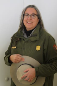
Lynne Dominy. Image credit: National Park Service
“Apostle Islands National Lakeshore offers world-class sea kayaking and sailing in a remote environment,” said Lynne Dominy, park superintendent. “But treacherous waves and frigid water temperatures can imperil boaters. We hope boaters will use this system to assess current conditions and to make good decisions before venturing out on Lake Superior.”
The site was developed as part of a yearlong project by the Department of Civil and Environmental Engineering at the University of Wisconsin-Madison and Wisconsin Sea Grant with advice from the National Park Service and the Wisconsin Coastal Management Program.
Chin Wu, project leader and a professor in the UW-Madison Department of Civil and Environmental Engineering, said spotter buoys were deployed in mid-June at the mainland sea caves, Sand Island, Devil’s Island, Stockton Island and southeast of Madeline Island, in addition to Chequamegon Bay and Siskiwit Bay.
“Besides the mainland sea caves, real-time measurements of wave heights and water temperatures have never been provided at these locations before,” Wu said. “The data we collect will also help us make nearshore wave and current forecast models operational.”
Next summer, a team led by Natalie Chin, Wisconsin Sea Grant climate and tourism outreach specialist, and Todd Breiby with the Wisconsin Coastal Management Program, will conduct a public survey to assess and evaluate the best ways to communicate real-time wave information. This could lead to refinements to the website and buoy locations.
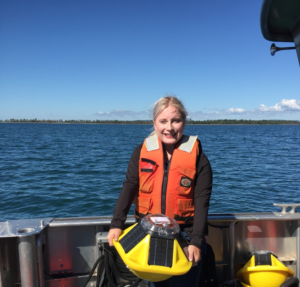
Sarah Peterson, a Ph.D. student at UW-Madison, holds one of the spotter sensors deployed in the Apostle Islands for the WISC-Watch Project. Image credit: Chin Wu
Water conditions around the 22 Apostle Islands vary dramatically due to sheltering effects from the archipelago and rapidly changing winds and fast-moving storms. Recent boating accidents are an unpleasant reminder of the dangers. Under certain conditions, freak waves, which can tower more than 10-feet tall, or unexpected dangerous currents can also occur.
The WISC-Watch Project was funded by the Wisconsin Coastal Management Program, Wisconsin Sea Grant and the UW-Madison Department of Civil and Environmental Engineering. Other project partners include the National Park Service, the National Weather Service in Duluth, the Red Cliff Band of Lake Superior Chippewa, the Wisconsin Department of Natural Resources, the Wisconsin Department of Tourism, the cities of Bayfield and Ashland, Northland College, the Lake Superior Nearshore Working Group, the Friends of the Apostle Islands and local outfitters.
Additional team members include Mike Friis with the Wisconsin Coastal Management Program, Jim Hurley and Marie Zhuikov with Wisconsin Sea Grant, Julie Van Stappen and Karl Carlson with the National Park Service, Josh Anderson with UW-Madison, and Mary Monroe Brown and Julieann Fox with Travel Wisconsin.