
LESSON SUMMARY
Students are reintroduced to the hydrologic cycle — the natural path water takes due to gravitational forces, beginning with precipitation, then infiltration or runoff, and finally via flow through rivers and wetlands as the water travels to Lake Michigan. Students are introduced to ways in which humans have altered the natural path of water flow (e.g., via installation of impermeable surfaces). Finally, students are exposed to the consequences of this interference by considering the impacts of stormwater management.
Because coastal waters are connected to surface water and groundwater via the hydrologic (water) cycle, students need to understand how engineers manage water movement within the entire watershed in addition to understanding how engineers use coastal structures to manage the movement of water and sediments along the coast.
LESSON CONCEPTS
- Water’s movements — both on the land and underground — cause weathering and erosion, which change the land’s surface features.
- The sustainability of human societies and the biodiversity that supports them require responsible management of natural resources. Scientists and engineers can make major contributions — for example, by developing technologies that produce less pollution and waste and that preclude ecosystem degradation.
LEARNING OBJECTIVES
Students can
- Identify at least two human actions or infrastructure elements that influence how water moves across the landscape.
- Generalize the natural path of water movement beginning with precipitation falling within the city of Racine and ending with water entering Lake Michigan.
- Generalize the path of water movement through storm water management infrastructure that is designed to move water from where it falls within the city of Racine to where it enters Lake Michigan.
- Make predictions related to how water will percolate through soil, and document whether their observations support their predictions.
The links below will download a Microsoft Word document or a Microsoft PowerPoint file. Note that Microsoft Word may not consistently hold formatting. The authors chose to provide Word documents rather than Adobe pdf files so the content can be easily updated for your geographic location.
- Detailed Version of Lesson 4 – Stormwater Management
- Educator Background Information Stormwater Management – Background
- Slideshow The Hydrologic Cycle
- Educator Activity Instructions Soil Infiltration and Percolation Test
- Student Handout Soil Infiltration & Percolation Test – Data Collection Sheet
- Slideshow Flooding at North Beach
- Slideshow Our Racine Today
- Assessment Lesson 4 Exit Slip
The link below will open a Google form.
|
|
ACTIVITY |
TIME NEEDED |
|
Lesson 4: What Is Stormwater? How Does It Fit with the Hydrologic Cycle? |
5 minutes |
|
|
Lesson 4: The Hydrologic Cycle slideshow |
5 minutes |
|
|
Lesson 4: Soil Infiltration and Percolation Test |
30 minutes |
|
|
Lesson 4: Stormwater Runoff Demonstration—Crumpled Paper Watershed |
10 minutes |
|
|
Lesson 4: Flooding at North Beach slideshow |
5 minutes |
|
|
Lesson 4: Our Racine Today slideshow |
5 minutes |
|
|
Lesson 4: Exit Slip |
5 minutes |
|
NEXT GENERATION SCIENCE STANDARDS
Develop a model to describe the cycling of Earth’s materials and the flow of energy that drives this process.
Develop a model to describe the cycling of water through Earth’s systems driven by energy from the sun and the force of gravity.
NGSS CROSS-CUTTING CONCEPTS
- Scale, proportion, and quantity. In considering phenomena, it is critical to recognize what is relevant at different measures of size, time, and energy and to recognize how change in scale, proportion, or quantity affect a system’s structure or performance.
- Structure and function. The way in which an object or living thing is shaped and its substructure determine many of its properties and functions.
WISCONSIN MODEL ACADEMIC STANDARDS FOR ENVIRONMENTAL LITERACY & SUSTAINABILITY
ELS.EX2.A.m Systems Thinking Create a model of a system, identify hidden relationships and perspectives, and analyze nested systems of its parts and wholes. Reorganize a system through analyzing alternative boundaries, perspectives, and relationships. Compare the relationship between two wholes by comparing the relationships of the parts.
WISCONSIN MODEL ACADEMIC STANDARDS FOR SCIENCE
MS-ESS2-2 Construct an explanation based on evidence for how geoscience processes have changed Earth’s surface at varying time and spatial scales.
SCI.ESS2.A.4 Earth Materials and Systems Rainfall helps to shape the land and affects the types of living things found in a region. Water, ice, wind, organisms, and gravity break rocks, soils, and sediments into smaller pieces and move them around.
SCI.ESS2.C.m The Role of Water in Earth’s Surface Processes Water cycles among land, ocean, and atmosphere, and is propelled by sunlight and gravity. Water movement causes weathering and erosion, changing landscape features.
SCI.ESS3.C.m Human Impacts on Earth’s Systems Human activities have altered the hydrosphere, atmosphere, and lithosphere which in turn has altered the biosphere. Activities and technologies can be engineered to reduce people’s impacts on Earth.
SCI.ETS2.B.m Influence of Engineering, Technology, and Science on Society and the Natural World All human activity draws on natural resources and has both short- and long-term consequences, positive as well as negative, for the health of people and the natural environment. The uses of technologies are driven by people’s needs, desires, and values; by the findings of scientific research; and by differences in such factors as climate, natural resources, and economic conditions. Technology use varies over time and from region to region.
SCI.SEP2.m Developing and Using Models Students develop, use, and revise models to describe, test, and predict more abstract phenomena and design systems.
Great Lakes Literacy Principles
- Principle 1: The Great Lakes, bodies of fresh water with many features, are connected to each other and to the world ocean.
- 1D: Rivers and streams transport nutrients, dissolved gases, salts and minerals, sediments and pollutants from watersheds into the Great Lakes.
- 1E: The Great Lakes are an integral part of the water cycle and are connected to the region’s watersheds and water systems. Changes in water systems affect the quality, quantity and movement of water, including retention time.
- Principle 6. The Great Lakes and humans in their watersheds are inextricably interconnected.
- 6C: The Great Lakes are affected directly by the decisions and actions of people throughout its watershed which includes parts of the states of Illinois, Indiana, Michigan, Minnesota, Ohio, Pennsylvania, New York, and Wisconsin, the Canadian provinces of Ontario and Quebec, and tribal lands.
- 6D: Local and national laws, regulations and resource management affect what is put into and taken out of the Great Lakes. Shoreline development and industrial or commercial activities lead to point and nonpoint source pollution.
- 6E: Coastal regions along the Great Lakes are impacted by land use decisions and natural hazards. Physical modifications (changes to beaches, shores, and rivers) can exacerbate effects of erosion, storm surges, and lake level changes.
- 6F: To ensure continued availability of Great Lakes assets, people must live in ways that sustain the lakes. Individual and collective actions are needed to effectively conserve and manage Great Lakes resources for the benefit of all.
(Source: Ohio Sea Grant. (2013). Great Lakes Literacy: Essential Principles and Fundamental Concepts for Great Lakes Learning. OHSU-B-090. National Science Foundation, National Oceanic and Atmospheric Administration, Sea Grant Great Lakes Network, Centers for Ocean Sciences Education Excellence (COSEE))
Complete list of Great Lakes Literacy Principles available at: www.cgll.org
Key Vocabulary
Evaporation The process of changing from liquid to gas. Evaporation releases water on the land and in lakes and rivers into the atmosphere.
Groundwater Water beneath the ground. Groundwater flows through the spaces between soil particles or cracks in bedrock, which is the rock layer below the ground.
Groundwater table The boundary (not a straight line) between the saturated zone (where water fills the space between soil particles) and the unsaturated zone (where air fills the space between soil particles).
Impervious surface A surface that water cannot flow through. Impervious surfaces include roofs, streets and parking lots. Precipitation that falls on an impervious surface and does not evaporate becomes runoff.
Infiltration Movement of water into the ground. How fast water flows into the ground is called the infiltration rate.
Inflow An addition of water to a particular portion of the hydrologic system of the watershed, for example, water flowing in from an upstream lake.
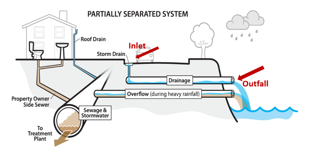
Inlet A point that collects runoff into the storm sewer pipes. Also known as a catch basin.
Outfall A point where a storm sewer empties into a lake, river or other water body.
Outflow A removal of water to a particular portion of the hydrologic system of the watershed, for example, water flowing out to a downstream lake.
Percolation Movement of water through the ground.
Pervious surface A surface that water can flow through. Pervious surfaces include lawns, forests and fields. Some water that falls on a pervious surface can infiltrate into the ground. The remaining water moves across the landscape as runoff.
Precipitation Water that falls from the sky, typically in the form of rain, snow, sleet, or hail.
Runoff Water that drains off the land. Water runs off the land when the rate of precipitation is greater than the combined infiltration, evaporation, and transpiration rates.
Storage In terms of stormwater management, a place that holds water. Some storm sewers drain through stormwater ponds, which temporarily store the stormwater and slowly release it to a lake, river, or other water body. This can help reduce flooding.
Stormwater Water on the landscape that originated as precipitation, including rain and melted snow or ice.
Transpiration The process of water movement through a plant. Plants’ roots take up water, which is transferred to the stems and leaves. The leaves of a plant transpire water into the atmosphere.
Treatment In terms of stormwater management, a technique used to remove pollutants from runoff. For example, stormwater ponds help solids settle out of the water before it reaches the final water body. Specially designed pipe systems can also remove solids. Wetlands can also help clean water.
Watershed An area or region that channels precipitation to a river, creek, lake or other water body.
This curriculum was prepared by Adam Bechle, Ginny Carlton, and Anne Moser under award number NA21NOS4290005 from the Great Lakes Bay Watershed Education and Training (B-WET) program of the National Oceanic and Atmospheric Administration (NOAA), U.S. Department of Commerce. The statements, findings, conclusions and recommendations are those of the author(s) and do not necessarily reflect the views of NOAA or the U.S. Department of Commerce.